
The City · The Archive · The Theatre · c. 210–1899
Begin in The City, follow its surviving records into The Archive, and watch its civic images perform in The Theatre. Read beside Invisible Maps of Trade, The League That Left No Map, Maps That Age and the collection catalogue.
Cities Remember
The map after the street
A city can forget in public. A gate is pulled down and its name remains on a road. A convent closes and the plot is divided. A defensive wall becomes a promenade. A stream is culverted, an alley widened, a district cleared for a station, a house renumbered, a property line preserved behind a new facade. The present city absorbs these changes so completely that the old order becomes difficult to see while walking through it.
The map is often asked to repair that loss. Put an earlier plan beside a modern one, we are told, and the buried city will reappear. The invitation is powerful because maps make difference look inspectable. Two streets coincide; a vanished wall cuts across a square; a church survives while the houses around it have changed. The map seems to remember what the city has forgotten.
But a map does not remember like a witness with a complete view. It remembers according to its material, purpose and institutional life. A marble cadastral plan cuts selected architecture into stone. A printed prospect turns a city into a spectacle. A surveyed ichnographic plan distinguishes forms of public access. A fire insurance sheet classifies construction and hazard for underwriters. Each preserves something by making other things peripheral or absent.
That selectivity is not a defect to be corrected by adding enough layers. It is the historical subject. A city map carries forward an argument about which urban facts can be stabilised: walls, monuments, parcels, routes, interiors, values, dangers. Later readers inherit both the information and the original terms of attention.
This essay follows nine maps and map systems across that problem. Rome is the main thread, from the surviving fragments of the Severan marble plan through Leonardo Bufalini and Giambattista Nolli. Nuremberg, Venice, London and Paris show the city performed as a whole. Buffalo’s Sanborn sheets reveal a different memory, organised around combustible materials and commercial risk. Together they show why “the city” on a map is never simply an area. It is an edited relationship between ground, building, institution and future use.
 The Archive
 The Forma Urbis Romae begins with an apparent promise of totality. Made in the early third century, the enormous marble plan was mounted on a wall in the Temple of Peace complex. The Stanford Digital Forma Urbis project describes a surface roughly 18.1 metres wide and 13 metres high, with architecture engraved at about 1:240. Rooms, walls, columns and stairways were cut at a scale capable of making the built city extraordinarily specific.
The plan’s survival reverses that scale. It is known through 1,186 fragments rather than one intact image. The pieces range from substantial assemblies to small engraved remnants whose place in Rome is unknown. The city reaches us not as a miniature whole but as a problem of joins, attributions and absences.
This matters because reconstruction is easily disguised by the confidence of a diagram. A fragment physically joined to another fragment occupies a different evidentiary state from one associated with a district because it depicts a recognisable structure. A piece with a few walls but no secure location is different again. If all three appear in the same line weight on a completed plan, the reconstruction erases its own reasoning.
The ledger below does not republish Stanford’s protected project photography and does not claim to replace its searchable record. It stages the editorial distinction that this essay needs. “Joined” refers to material or securely continuous evidence. “Proposed location” refers to an attribution that should remain contestable. “Unplaced” refuses the visual temptation to fill the blank.
Evidence register
What kind of “place” does a fragment have?
Showing 6 fragments across three evidence states.
-
Physically joined
Fragment 10a
A physical join and continuous wall lines place this piece within a known slab group.
-
Proposed location
Fragment 24c
Architectural form supports a proposed district, but the fragment has no secure physical join.
-
Unplaced
Fragment 31bb
The surviving incisions preserve a building, not enough context to place it safely in Rome.
-
Physically joined
Fragment 37a
Break edges and the continuation of engraved geometry support its position in a larger assembly.
-
Proposed location
Fragment 46
A named or recognisable structure suggests a neighbourhood without resolving the whole slab.
-
Unplaced
Unnumbered remainder
A legible plan survives while its address does not. It remains evidence without a recovered location.
Illustrative evidence classes, not a republication of the Stanford fragment photography. Fragment identifiers demonstrate the editorial rule: a proposed location is never displayed as a physical join. Inspect the searchable source record at Stanford Digital Forma Urbis.
The blank is itself information. According to the project’s account, the marble plan privileged architecture. Political and sacred boundaries were not drawn as a separate thematic system. Even the Tiber is legible largely through the space left between built edges. The city remembered in marble is therefore not the total city of inhabitants, sounds, rights and movement. It is a city made durable as architectural ground.
Later plans of Rome can appear to complete what the fragments lost. Bufalini’s 1551 plan and Nolli’s 1748 plan provide continuous printed surfaces, named places and a recognisable relation to the modern city. Yet they do not restore the Severan map. They record other Romes through other instruments and institutions. To place a fragment beside Nolli is useful only when the gap of fifteen centuries remains visible. The later plan can supply orientation; it cannot convert a proposed ancient location into a physical join.
This is the first way a city map remembers: not by overcoming ruin, but by letting a surviving mark carry an incomplete address. The archive becomes more truthful when it distinguishes the strength of that address instead of drawing every fragment home.
 The Theatre
 A city portrait answers a different desire. Where the fragmented plan frustrates the whole, the printed view offers the whole immediately. Walls enclose it. Towers rise above it. Streets, roofs, markets and churches settle into one visual body. The viewer stands outside, above or impossibly across from the city and sees more than a single human position could reveal.
The 1493 Nuremberg view in the Liber Chronicarum announces “Nuremberga” above a concentrated walled settlement. Named churches and gates organise recognition. Buildings crowd toward the right edge while an approach road leads the eye into a defended civic body. The page does not behave like a modern measured plan. It makes Nuremberg memorable through profile, enclosure and emblematic density.
Jacopo de’ Barbari’s View of Venice of 1500 expands this performance to monumental scale. Printed from six woodblocks, the lagoon city becomes a single inspectable object surrounded by water, shipping and divine winds. Its immense detail promises local knowledge, but the viewing position is constructed. No observer could occupy the air above the lagoon and see every roof, canal and island in this way.
That impossibility is not evidence that the view is careless. It is how the image does civic work. Venice appears self-contained yet connected to movement. Its waterborne edges are clear; its buildings form a dense, controlled surface; Mercury hovers over a commercial republic that can be apprehended as a whole. The view remembers Venice as the city wished to become visible.
The comparison below brings Nuremberg’s book-page city beside one sheet of Nolli’s surveyed Rome. The images differ in date, scale, crop and purpose, so the slider is not a registration. It asks what kind of recognition each image produces. In the chronicle view, towers and walls let the city perform its identity. In Nolli, a plan reader enters a field of streets, blocks and accessible interiors.


The distinction becomes more consequential with Braun and Hogenberg’s Civitates Orbis Terrarum, begun in 1572. Hundreds of plans and prospects place different cities inside a repeatable atlas form, accompanied by descriptive texts. Local identity becomes comparable. Dress, wall, skyline, street and setting can be read across pages as elements of an urban genre.
Comparison preserves and flattens at once. It makes distant cities available to the same reader, but it encourages each place to become a specimen of “the city.” The atlas remembers a civic world through the regularity of its own sequence. The individual image might insist on local monument or costume; the volume teaches the reader to move from city to city.
This is why a historical view should not be treated merely as a less accurate plan. Its truth lies partly in performance. It records what could be made to stand for the city: enclosure, abundance, sacred prominence, commercial access, recognisable profile. A wall on such an image is fortification, edge and emblem at the same time.
Walls are among the easiest urban memories to narrate. They draw a boundary, they survive in place-names, and their removal often produces boulevards or ring roads whose shape remains visible on later maps. Put two plans side by side and the story appears clean: enclosure, demolition, expansion.
Historical maps complicate that sequence because a wall can outlive its military function inside the image. It continues to define the city long after settlement has grown beyond it. It can be copied from an older source, emphasised for civic identity or retained because a publisher’s plate still carries the line. The mapped wall has its own life, neither identical to standing masonry nor simply false.
Bufalini’s Rome of 1551 demonstrates the authority of a continuous printed plan at a moment when ancient fabric, papal intervention and contemporary streets coexisted. The Aurelian Walls supply a powerful perimeter, yet the city inside is uneven. Large tracts within the ancient circuit were not densely built. The inherited enclosure remembers an imperial scale that the sixteenth-century settlement did not uniformly occupy.
The so-called Agas map of London creates a similarly compelling urban body. Its woodcut tradition presents streets, buildings, river traffic and walls in a bird’s-eye language. The University of Victoria’s Map of Early Modern London now turns the image into a scholarly, hyperlinked environment. A historic view becomes an index: a gate, parish or street can connect to textual records and later knowledge.
The digital edition does more than reproduce memory. It reorganises it. Search, links and scholarly entries make features available in ways the original printed surface could not. The old wall remains visible, but it now participates in a new system of addresses. That transformation is valuable precisely because it is acknowledged as an edition rather than disguised as unmediated access to London.
Louis Bretez’s great perspective plan of Paris, commonly called the Turgot map, offers another form of afterlife. Commissioned in the eighteenth century and issued in twenty sectional plates with a key, it presents Paris from an oblique viewpoint while allowing the city to be assembled as a grand whole. Buildings and gardens rise; streets remain traceable; the surrounding edge stages an urban order for inspection.
Across these maps, a boundary can remember several cities at once: the legal city, the defended city, the built-up city and the city as a publisher or patron wishes it seen. Demolition does not reduce those meanings to a single before-and-after line. When a later boulevard follows a former wall, the continuity is spatial. When a printed wall persists after material change, the continuity is representational. Both are historical, but they are different claims.
The responsible map interface should therefore ask what has persisted. Is the geometry derived from a survey or copied from another print? Does a wall line mark standing fabric, jurisdiction, memory or graphic convention? “Still visible” is an invitation to investigate, not an answer.
 The Map
 Nolli’s Nuova Pianta di Roma is often celebrated for the way its figure-ground language joins streets and certain accessible interiors into a continuous white field. Churches, courtyards and other spaces that a reader could enter participate in the public texture; private building mass is dark. The result makes urban access legible without reducing it to the open air.
That visual grammar is a form of memory. A modern street map generally preserves the route through Rome and labels major monuments, but it may not reproduce the same distinction between accessible interior and private mass. Nolli records a social and architectural relation that can disappear even where the building remains.
It would be easy to call the white field “public space” and treat it as a timeless property. The term needs care. Access was conditioned by institution, custom, time, status and use. A church interior was not the same political space as a street. The plan’s graphic continuity is analytically fertile because it draws them together; it should not make their differences vanish.
The overlay below places one Nolli sheet above an OpenStreetMap-derived image of modern Rome. The opacity control gives the historical engraving enough instability to be inspected rather than accepted. Move it toward zero to read the present map; increase it to let Nolli’s linework dominate. Notice how quickly apparent coincidence produces confidence.
Exploratory registration · Rome
Nolli over a modern street map
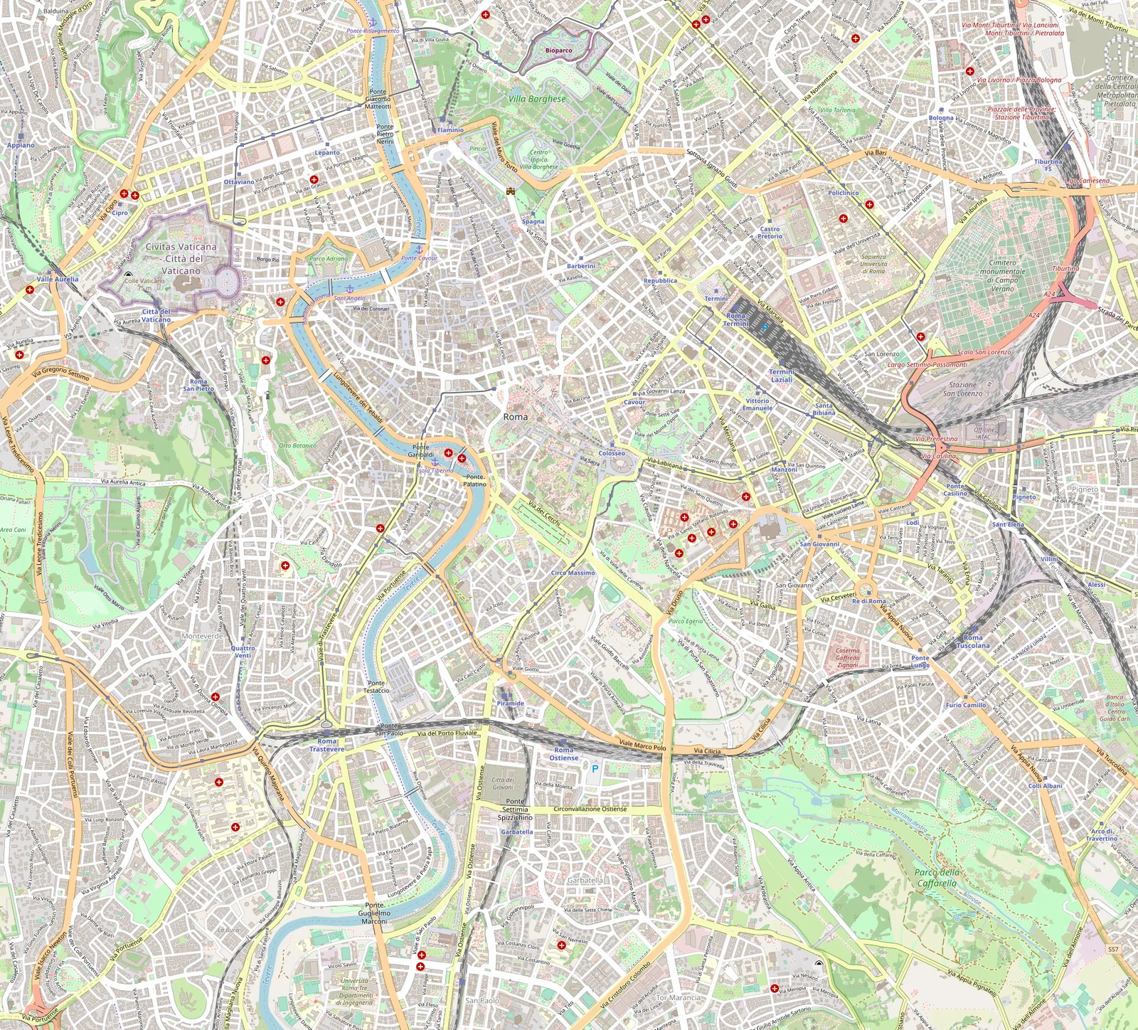

The annotation behind the overlay follows the W3C/IIIF georeferencing form used by Allmaps: a source image and mask are attached to geographic control points. Publishing those points matters because “georeferenced” should not function as a magical label. Another reader can inspect what was matched and reject the registration.
This particular registration is explicitly exploratory. It uses four approximate visual correspondences on a cropped reproduction. It has no calculated, evidence-grade residual. The modern image uses a web-map projection and the engraved sheet contains its own distortions. A convincing local overlap can sit beside a substantial error elsewhere.
The warning changes how the overlay should be read. If an old street and a modern street appear to coincide, the interface has generated a hypothesis. Verification requires a better georeferencing model, documented control points, residual analysis and often other survey or cadastral evidence. If a church footprint seems stable, the image still cannot establish uninterrupted access, fabric or ownership.
This does not make the overlay useless. It makes its use specific. The layer helps a reader identify where to look and what kind of persistence might be at stake. It returns Nolli’s public-private grammar to the present city as a question.
The Sanborn fire insurance maps remember a city for a reader who may never visit it. Their audience needed to judge risk: construction material, building use, water supply, street width, openings, fire protection and the proximity of hazardous activities. The sheets are exceptionally detailed because insurance required detail, not because the map aspired to preserve every urban fact.
Buffalo’s 1899 volume belongs to that system. Across more than a hundred sheets, the city becomes an inventory of blocks and structures. Colour, abbreviations and symbols support comparison. A building is not only a shape but a bundle of attributes relevant to loss. The map’s apparent intimacy with the block is institutional: it sees through the priorities of underwriting.
That purpose produces a powerful afterlife. Historians, residents, planners and environmental researchers use Sanborn maps to locate disappeared factories, tenements, yards, tanks and services. The commercial classification built for one future-the probability and cost of fire-becomes evidence for many later pasts.
The transfer is never neutral. What an insurer recorded in precise colour can seem more historically real than what the sheet omitted. Household relations, informal uses, racial exclusion, tenancy and daily movement may be essential to the life of the block without occupying equivalent graphic space. The map remembers the building as a risk object more readily than the building as a home.
Revision deepens the problem. Sanborn sheets could be updated through paste-on corrections and later editions. A map that appears to describe one date might carry material from several observations. The archive must distinguish edition, sheet and revision rather than assign the entire image one stable birthday. In this respect, the insurance map belongs beside Maps That Age: the physical carrier can become a record of repeated institutional attention.
The map is therefore neither an innocent snapshot nor only an instrument of power. It is a highly structured witness. Its classifications can recover vanished urban fabric with astonishing specificity, while the reasons for that specificity constrain what the evidence means.
When a Sanborn block is overlaid on a present parcel map, the same discipline applies as with Nolli. A footprint correspondence is not a complete social continuity. It may establish that a structure occupied a location or that a use was recorded there. It cannot by itself tell us whose memory survived, who was displaced, or which unmapped practices gave the block its life.
Every overlay chooses a common ground. Two images must be cropped, transformed and ordered. One becomes the base; another becomes the layer. Control points declare that selected marks refer to the same places. Opacity decides which image dominates. Even a technically excellent registration is therefore an interpretation before it is a discovery.
The strongest version of the tool makes those decisions inspectable. It identifies the source images and rights. It publishes the annotation. It labels estimated or uncalculated error. It distinguishes a visual correspondence from a historical claim. It lets a reader reduce the historical layer instead of trapping the present under it.
The weakest version offers wonder without friction: “then and now” perfectly fused, with no account of projection, crop, survey, revision or control points. The result can turn geometric resemblance into a myth of urban persistence. A street seems ancient because two strokes meet. A boundary seems natural because it survives on several maps. A demolished district becomes legible as empty space without the violence or administration that produced the clearing.
The nine records in this essay suggest a different practice.
From the Forma Urbis, keep the evidence state attached to the fragment. Do not allow a reconstructed whole to erase the distinction between physical join and proposed location.
From Nuremberg, Venice and the Civitates, recognise the city portrait as a performance. Perspective and enclosure are not failed survey; they are techniques for making civic identity visible and comparable.
From Bufalini, the Agas tradition and Turgot, ask which boundary or monument the printed city carries forward, and whether the persistence belongs to the ground, the plate, the edition or the patron’s urban idea.
From Nolli, preserve the map’s analysis of access without converting white and black into timeless public and private categories. Let georeferencing open a question, then publish enough evidence for the registration to be challenged.
From Sanborn, use extraordinary block detail while retaining the commercial purpose that selected it. A risk map can remember vanished industry and still remain silent about much of urban life.
These are not reasons to distrust city maps. They are reasons to grant them historical depth. A map does not merely store an earlier arrangement of streets. It stores a way of observing, classifying and revising the city. When that map is digitised, linked and overlaid, its way of seeing becomes actionable again.
The city remembers through fabric, names, habits and institutions. The map remembers through material marks, graphic conventions, copies, repairs, catalogues and new interfaces. Sometimes the two memories coincide. Sometimes the map preserves what the street has lost. Sometimes it perpetuates an order the city has outgrown.
The task is not to make the past perfectly transparent over the present. It is to show the seam: where an old claim has been fitted to new ground, where the match is strong, where it fails, and what each layer was built to see.
Map credits and source records
- Forma Urbis Romae: Stanford Digital Forma Urbis project record and measurements; project photography is not republished here.
- Nuremberg, Liber Chronicarum, 1493: digitised public-domain page from the Bavarian State Library witness, delivered by the Library of Congress World Digital Library record.
- View of Venice, 1500: Jacopo de’ Barbari and Anton Kolb; Minneapolis Institute of Art collection record and public-domain reproduction.
- Bufalini, Agas, Civitates, Turgot and Nolli: linked institutional or public-domain source records in the collection catalogue.
- Sanborn Buffalo, volume 1, 1899: Library of Congress Geography and Map Division, public-domain online collection.
- Modern Rome basemap: © OpenStreetMap contributors, Open Database License. Static derived image distributed under CC BY-SA 2.0; file donor also marked the image CC0.
Further reading
- Jennifer Trimble, Marc Levoy and Tina Najbjerg,
Stanford Digital Forma Urbis Romae Project
. - Minneapolis Institute of Art,
Jacopo de’ Barbari, View of Venice
. - Map of Early Modern London, The Agas Map of Early Modern London.
- Library of Congress, Civitates Orbis Terrarum .
- James Tice and Erik Steiner, The Interactive Nolli Map Website.
- Library of Congress,
About the Sanborn Maps Collection
. - Allmaps, Georeference Annotation documentation.