
Room 5 of 7
The Road
Travel, trade, and exploration - the world experienced as movement and route.
Some maps are not drawn from above but travelled from within - the world known as a sequence of passages, ports, and stages rather than a territory surveyed whole. The Road is the room of movement: trade routes, itineraries, and voyages of exploration, space experienced as the distance between one place and the next. It asks how the world looks to those who cross it - how a merchant’s sea of connected harbours differs from a state’s administered land, two rival ideologies of space meeting on the same water. To map the route is to privilege the line of travel over the ground it passes, the network over the territory. Here we follow the map that serves the journey - and ask what it must ignore about everything that lies to either side of the road.
The room's anchor
La Rotta e il Catasto
Venice, Sicily, and Two Ways of Drawing the Same Sea
Six centuries of Mediterranean cartography set as a duel: Venice's maritime network against Sicily's administered territory - two ideologies of space drawn onto one sea.
Essays in this room
Essays that pass through
Chapters in this room
- The route, harbour by harbour in La Rotta e il Catasto
- The road becomes devotion in Invisible Maps of Religion
- Routes before surfaces in The Shape of a Civilization
- Remove the network in The League That Left No Map
- Merchants before the League in The League That Left No Map
- Goods draw different leagues in The League That Left No Map
- A sea between cities in The League That Left No Map
- The sea-state, drawn and undrawn in La Rotta e il Catasto
- The boundary of this argument in Invisible Maps of Religion
- Four cities inside other cities in The League That Left No Map
- The city is the unit in The League That Left No Map
- Power without sovereignty in The League That Left No Map
- The charter is a map in The League That Left No Map
- The sea becomes legible as the institution fragments in The League That Left No Map
Atlas layers
- Natural Earth - Rivers Major river and lake centrelines - waterways that carried maps and trade.
- Venetian maritime ports, c.1200–1500 Stato da màr nodes - the metropole and its capital, subject cities, colonies and independent rivals - graduated by status, each phase a separate feature.
- Venetian galley routes (mude), c.1200–1500 The documented muda convoy lines and private round-ship trades, dashed by route_type and routed through their staging ports.
- Venetian possessions, c.1200–1500 Territorial extent of the stato da màr - direct rule, protectorates, condominia and contested ground - as phased fills clipped to the coastline.
- Hanseatic places and participation phases Sixty source-linked city, market and Kontor phases with historical and modern names and explicit participation classes.
- Hanseatic trade corridors Seven evidence-labelled maritime, riverine, overland and mixed corridors with normalized commodity joins.
- Hanseatic institutional events Privileges, ordinances, embargoes, conflict, treaties, Hansetage, Kontor closures and institutional afterlives.
- Roman Dacia · roads and frontier corridors The province drawn as a network: roads are lines through attested stations, and the limes are corridors this project drew. Nothing here is digitised from a survey, and the dashes say which is which.
- Antarctic expedition tracks (unreviewed) Where ships went, and how they got there. A planned crossing, a voyage under sail and a drift with the ice are three different kinds of line, and the encoding says which is which: nothing here that Terra Chartarum drew is rendered as though a source had given it.
- Matthew Paris itinerary: stages at modern positions (unreviewed) Fourteen stages of the drawn road from London to Otranto, placed at the modern coordinates of the towns they name. The manuscript gives no coordinates at all, so the positions are reference context and the labels and day-marks are the evidence.
- Fourth Crusade: the routes travelled (unreviewed) Venice to Zara, and Zara through Corfu to Constantinople. Two generalisations between ports, because no source in the corpus gives a track. What the crusade intended, what it claimed and what it eventually held are separate records with no geometry at all.
- Fourth Crusade: diversion and assaults (unreviewed) Three events at two places: the diversion to Zara in 1202, and the assaults on Constantinople in 1203 and 1204. An event is not a territory, and the position is the place, not the state.
- The Holy Land as a network: the ports (unreviewed) Four ports the sacred centre was reached, administered and supplied through. The other six records in this register - the world images, the itinerary’s destination, the described land, the gridded sheet and the later emblem - carry no position at all, because what they record is not one.
Collection sheets
-
 Madaba mosaic map, Jerusalem detail A sixth-century church-floor mosaic enlarges Jerusalem into a legible sacred city and destination.
 -
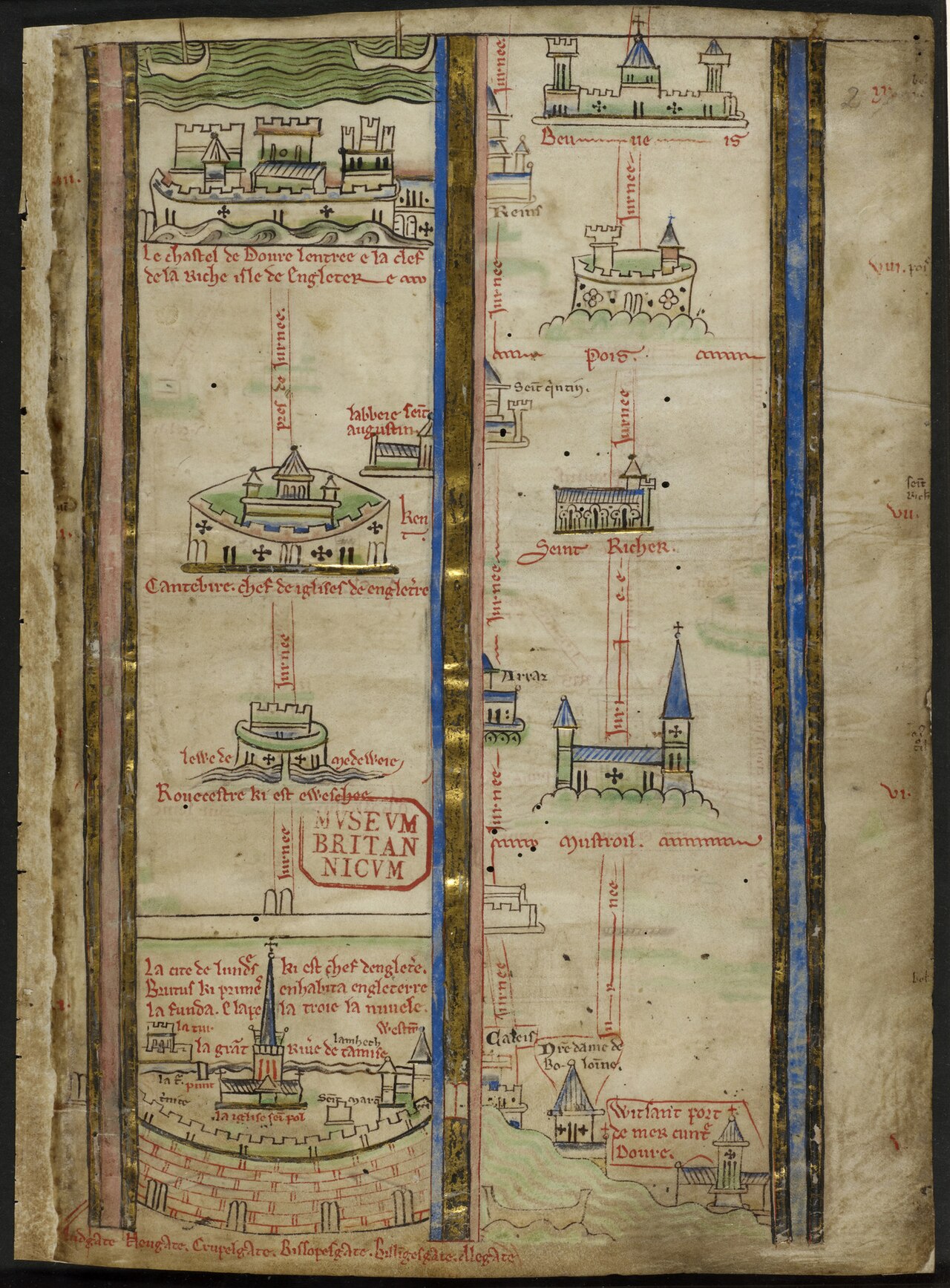 Itinerary from London toward Jerusalem Matthew Paris turns pilgrimage into a vertical sequence of cities, seas and stations rather than a uniform surface.
 -
 Carta Pisana The oldest surviving portolan - the sea as a web of bearings.
 -
 Fra Mauro world map Venice's encyclopaedic world, drawn south-up.
 - Al-Idrisi's Tabula Rogeriana Made at the Norman court of Palermo for Roger II.
-
 Portolan chart of the Mediterranean and Black Seas An anonymous vellum chart turns the Mediterranean and Black Seas into a continuous field of named coasts and bearings.
 -
 Eastern Mediterranean portolan Pietro Vesconte’s signed chart presents the eastern Mediterranean as an ordered sequence of coasts and crossings.
 -
%20atlas.jpg?width=1400) Western Mediterranean from a portolan atlas A western Mediterranean atlas leaf extends Vesconte’s navigational grammar across a second maritime field.
Western Mediterranean from a portolan atlas A western Mediterranean atlas leaf extends Vesconte’s navigational grammar across a second maritime field. - Portolan leaves from the Andrea Bianco atlas Andrea Bianco’s atlas binds portolan leaves, tables and cosmographic material into one Venetian working manuscript.
-
.png?width=1600) Portolan chart of the Mediterranean Petrus Roselli’s chart preserves the dense coastal names and rhumb network of the Majorcan portolan tradition.
Portolan chart of the Mediterranean Petrus Roselli’s chart preserves the dense coastal names and rhumb network of the Majorcan portolan tradition. - Portolan atlas of nine charts and a world map Battista Agnese’s workshop joins navigational charts and a world map in a richly illuminated Venetian atlas.
-
 View of Venice Jacopo de’ Barbari turns the lagoon into an inspectable city while the wider commercial network remains beyond the frame.
 - Tabula Peutingeriana The road as the unit of space - Dacia stretched along an itinerary.
- Rudimentum Novitiorum world map, Lübeck copy witness A world map printed in Lübeck names northern regions but does not draw the commercial institution around its press.
- Carta Marina et descriptio septemtrionalium terrarum Olaus Magnus makes the northern seas dense with places, creatures and movement as Hanseatic institutions enter a later phase.
- Lübeck, from Civitates Orbis Terrarum, volume I The engraved city portrait calls Lübeck head of the Wendish cities and the Hanseatic society while presenting an autonomous imperial city.
- Hamburg, from Civitates Orbis Terrarum, volume I A river city is made visible as a civic body while the commercial relationships extending beyond it remain implicit.
- London and the Stilliards, from Civitates Orbis Terrarum The London plate pairs an urban view with a text naming the Steelyard, four Kontore and a confederated society of cities.
- Bruges, from Civitates Orbis Terrarum, volume I A circular city portrait describes Bruges as having once been a flourishing emporium without fixing a single date for decline.
- Cologne, from Civitates Orbis Terrarum, volume I The Rhine city’s plate names a league of seventy-two cities and four principal cities, a claim kept distinct from the four Kontore.
- Bremen, from the four-city Civitates plate Bremen appears as a river prospect on a sheet whose Lüneburg panel also names the salt economy behind a major corridor.
- Second Novgorod Schra, Riga copy A sixty-four-article rule text makes Peterhof’s internal discipline visible without turning the merchant compound into territory.
- Bergen Kontor court books, 1633–1759 Nine court books record internal jurisdiction, fees, fire safety, office holders and price lists across Bryggen’s long afterlife.
- London Kontor by-laws, 1554 Thirty leaves regulate elections, jurisdiction, finance, conduct and training inside the Steelyard community.
- Bruges privilege charters, 1458–1502 A charter group records building, staple and excise privileges as negotiated access inside a host city.